
BASIC INFO: auf Deutsch - in english - en français - ve Türkçe
Περιπλάνηση στο μακρινό παρελθόν με οδηγό την φαντασία, μέσα στο ''Δάσος της Σιωπής''
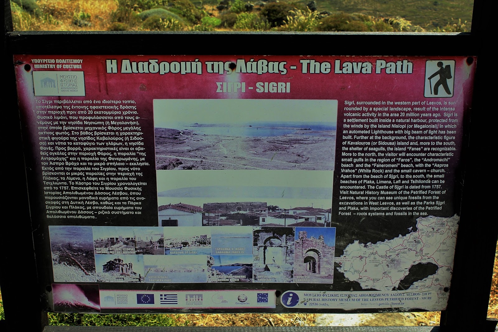
Άλλη μία περιοχή της όμορφης Πατρίδας μας, που για χρόνια βρισκόταν στο στόχαστρο μου!
Το Απολιθωμένο Δάσος της Λέσβου, είναι ένα μοναδικό τεκμήριο της γεωλογικής ιστορίας, το οποίο έχει κηρυχθεί «Διατηρητέο Μνημείο της Φύσης», από το 1985.
Απολιθωμένοι κορμοί βρίσκονται διάσπαρτοι σε μία έκταση 150 τετραγωνικών χιλιομέτρων που περικλείεται από τους οικισμούς Σίγρι, Ερεσός και Άντισσα στη δυτική Λέσβο. Μεμονωμένα
απολιθώματα βρίσκονται και σε πολλά άλλα μέρη του νησιού, συμπεριλαμβανομένων των χωριών Μόλυβος, Πολιχνίτος, Πλωμάρι και Άκρασι.
Ο σχηματισμός του απολιθωμένου δάσους σχετίζεται με την έντονη ηφαιστειακή δραστηριότητα που έλαβε χώρα στη Λέσβο κατά το τέλος του Ολιγοκαίνου μέχρι το μέσο Μειόκαινο, περίπου πριν 20 εκατομμύρια χρόνια.

Το 1987 πραγματοποιήθηκαν οι πρώτες ανασκαφές στο Πάρκο Απολιθωμένο Δάσος Λέσβου, το πρώτο πάρκο που δημιουργήθηκε, ενώ από το 1997 πραγματοποιούνται συστηματικές ανασκαφές από το Μουσείο Φυσικής Ιστορίας Απολιθωμένου Δάσους Λέσβου. Το Μουσείο ιδρύθηκε το 1994 στο Σίγρι και έχει ως σκοπό την μελέτη, ανάδειξη και προστασία του Απολιθωμένου Δάσους. Από το 2000, το Μουσείο είναι ιδρυτικό μέλος του δικτύου Ευρωπαϊκών Γεωπάρκων και το 2004 εντάχθηκε στο Παγκόσμιο Δίκτυο Γεωπάρκων της UNESCO. Υπάρχουν άλλες πέντε προστατευόμενες εκτάσεις, το πάρκο Πλάκας, το πάρκο Σιγρίου, το πάρκο Νησιώπης και το πάρκο Χαμανδρούλα. Την 21η Σεπτεμβρίου του 2012, ύστερα από σχετική εισήγηση, η UNESCO ενέκρινε την υποψηφιότητα της Λέσβου και την ενέταξε ολόκληρη στο Παγκόσμιο Δίκτυο Γεωπάρκων.

Η θέση «Μπαλή Αλώνια», όπου βρίσκεται το πάρκο απολιθωμένου δάσους, ήταν γνωστή το 18ο αιώνα με το όνομα «Κύρια απολοθωμένη» εξαιτίας του μεγάλου αριθμού απολιθωμάτων. Η έκταση αυτή, μαζί με τη θέση Χαμανδρούλα κοντά στην Ερεσό (κάπου, κάπου παίρνουν και σωστές αποφάσεις), απαλλοτριώθηκε από το ελληνικό δημόσιο το 1966, σύμφωνα με την απόφαση του Υπουργείου Οικονομικών και Γεωργίας, έτσι ώστε να προστατευθούν και να αναδειχθούν τα απολιθώματα.
Κατά τη διάρκεια διάνοιξης των περιπατητικών διαδρομών το 1987 έγιναν και οι πρώτες ανασκαφές απολιθωμένων κορμών, όπως ενός κατακείμενου κορμού μήκους 20 μέτρων που βρέθηκε κοντά στην είσοδο του πάρκου.
Κατά τη διάρκεια διάνοιξης των περιπατητικών διαδρομών το 1987 έγιναν και οι πρώτες ανασκαφές απολιθωμένων κορμών, όπως ενός κατακείμενου κορμού μήκους 20 μέτρων που βρέθηκε κοντά στην είσοδο του πάρκου.
Ο επισκέπτης του Πάρκου μπορεί να περιπλανηθεί σε μια ολόκληρη βουνοπλαγιά, από ειδικά διαμορφωμένα μονοπάτια και να θαυμάσει τις μοναδικές εμφανίσεις Πρωτοπευκιδών, που σχηματίζουν μικρές συστάδες και αποτελούν τους προγόνους του σύγχρονου Πεύκου, καθώς και προγονικές μορφές του σύγχρονου είδους Σεκόια η Αειθαλής που φύεται στις δυτικές ακτές των Ηνωμένων Πολιτειών.
Τα αγγειόσπερμα – ανθοφόρα φυτά περιλαμβάνουν αντιπρόσωπους των ειδών Λεύκα, Δάφνη, Κανελλόδενδρο, Πλάτανος, Δρυς, Οξιά, Σκλήθρο, Βάτος, Σφένδαμος και Καρυδιά. Επίσης, έχουν προσδιοριστεί πολλά είδη φοινικίδων.

Το Απολιθωμένο Δάσος της Λέσβου, με τον μεγαλύτερο σε διάμετρο όρθιο κορμό στον κόσμο, περιμέτρου 13,7 μέτρων και με 7,02 μέτρα, τον υψηλότερο όρθιο κορμό στην Ευρώπη, δεν είναι μόνο το δεύτερο μεγαλύτερο του είδους του στην οικουμένη, (μετά το Εθνικό Πάρκο Απολιθωμένου Δάσους της Αριζόνας), αλλά και μία τρανή απόδειξη του πανίσχυρου μεγαλείου της Φύσης.
Der Versteinerte Wald von Lesbos Europäischer und UNESCO Globaler Geopark
An der Westküste der Griechischen Insel Lesbos in der nordöstlichen Ägäis, wo Vulkangestein auf das azurblaue Meer trifft, haben die Wellen über eine lange Zeit die Überreste versteinerter Pflanzen aus der fernen Vergangenheit freigelegt. Die wahre Pracht der stehenden fossilen Stämme und die wilde Herrlichkeit der Vulkanlandschaft ist die unbeschreiblichen Brillanz, Schönheit und Lebhaftigkeit der Farben.
Die bemerkenswertesten Ansammlungen von versteinerten Stämmen die den berühmten „Versteinerten Wald“ bilden, befinden sich in den Regionen Sigri, Antissa und Eresos. Außer den versteinerten Baumstämmen findet man hier auch perfekt erhaltene Wurzeln, Früchte, Blätter und Samen.
Die große Anzahl aufrecht stehender Baumstämme mit intakten Wurzelsystemen beweisen, dass diese Bäume in Originalstellung versteinert wurden. In anderen Worten handelt es sich hier um einen autochthonen versteinerten Wald.
Das Naturkundliche Museum des versteinerten Wald von Lesbos befindet sich an der Westküste der Insel in Sigri und wurde 1994 eröffnet. Der Versteinerte Wald entstand vor 20 Millionen Jahren in einer Zeit intensiver vulkanischen Aktivität in der Nordägäis. Damals entstanden mehrere vulkanische Zentren im zentralen Teil der Insel.
Der dichte Wald der damals im Westen der Insel existierte wurde in dieser Zeit von einem riesigen pyroklastischen Strom und Asche begraben.
Im Museum werden Funde aus dem Versteinerten Wald ausgestellt und die geologische Entwicklung der Ägäis erläutert, von der Entstehung des Versteinerten Waldes vor 20 Millionen Jahren bis hin zu den heutigen Ökosystemen. Danach können Besucher den Versteinerten Wald, den Sigri Geopark, Plaka Geopark, oder das Schutzgebiet Insel Nisiopi erkunden. Diese Orte sind durch Wanderwege miteinander vernetzt die dem Besucher ermöglichen die einzigartige natürliche Schönheit der vulkanischen Landschaft im Westen von Lesbos zu genießen die bis heute vom Menschen unbeschädigt erhalten geblieben ist.
Die perfekt erhaltenen fossilen Bäume die einen kompletten urzeitlichen Wald bilden, versetzen jeden Besucher in Erstaunen. Nirgendwo auf diesem Planeten gibt es so viele stehende fossile Baumstämme.

Petrified Forest of Lesvos
The island of Lesvos, located in the NE Aegean Sea is the 3rd largest Greek island, with an area of 1630 sq. km and a shape likened to a plane tree leaf.
Northern Aegean 20 million years ago, resulted in the creation of the Petrified Forest of Lesvos. Here one can find fossilised pieces of trees, scattered over an area of 150 square kilometres surrounded by the settlements of Sigri, Eressos and Antissa in western Lesvos,
– which in the remote past were once alive – standing upright or lying on the ground in a multitude of colours, with their roots and branches. Scientists who have studied the Petrified Forest speak with wonder of the uniqueness, rarity and great scientific value of the monument. The Petrified Forest provides considerable information regarding the composition and character of paleoflora and climatic conditions of the distant past.
Intense volcanic eruptions resulted in the flow of pyroclastic material and ash which eventually covered the whole of the area where the Petrified Forest now lies. The following nature’s activity led to a molecule-to-molecule substitution of the organic matter of the trees; and it was so perfect a substitution that not only the trunks but also roots, fruit, leaves and seeds, well protected within volcanic rocks, are astoundingly preserved. The huge environmental, geological and paleontological value of the Petrified Forest earned a national recognition when it was declared a Natural Monument by the Greek State, and an international one, when it became a founding member of the European Geoparks Network and a member of the Global Geoparks Network.
The rarity and uniqueness of the site meet no fair description by words. With hundreds of standing and fallen red, yellow, green and black trunks of conifers and other trees, with gigantic intact root systems, with the thickest standing petrified tree in the world (circumference of 13,7m) and with the tallest one in Europe (7,02m), the Petrified Forest of Lesvos is not only the second largest of its kind in the world, but also the ideal proof of the almighty magnificence of Nature.
La forêt pétrifiée de Lesbos,

est un des monuments plus fascinants et les plus rares du patrimoine géologique dans le monde. Sa création, 20.000 000 an est liée à l'activité volcanique intense de la mer Égée pendant la période du Miocène. En 1985, la forêt a été déclarée Monument naturel protégé.
La forêt pétrifiée de Lesbos est non seulement lα deuxième plus grand de sα genre dans le monde, mais aussi la preuve idéale de la magnificence de la nature tout-puissant.
Des travaux pour la construction d’une nouvelle route entre Kalloni et Sigri sur l’île de Lesvos, ont révélé de nouvelles traces de troncs d’arbres fossilisés et des vestiges d’une forêt antédiluvienne.
Des recherches ont été menées par des scientifiques du Musée d’Histoire Nationale de la Forêt Pétrifiée de Lesvos, responsable de la préservation de toute zone de forêt fossilisée trouvée sur l’île. Parmi les découvertes, on compte un nombre sans précédent de troncs d’arbres fossilisés, à la fois des conifères et des arbres à fleurs (angiospermes) tels des chênes, des séquoias, des lauriers, des palmiers, des cyprès et des pins. Prises au piège de couches volcaniques sont emprisonnées une grande variété d’espèces comme la cannelle, les noix, les palmiers et d’autres qui confirment la présence d’une forêt subtropicale, recouverte par des éruptions volcaniques successives et violentes.
 Midilli Taşlaşmış Ormanı,
Orman doğal anıt olarak ilan edilmiş ve korunmaya alınmıştır. Orman, Midilli Adası'nın batı kısmında birçok yerde bulunabilen fosilleşmiş bitkilerden oluşmuştur. Eressos, Antissa ve Sigri köylerinin çevrelediği alanda fosilleşmiş ağaç gövdeleri çok yoğundur. Bunlar Midilli Taşlaşmış Ormanı Doğal Tarih Müzesi tarafından yönetilmektedir.
Fosiller arasında farklı bitki türleri 40’a yakındır. Tarçın, palmiye, ıhlamur, kayın, meşe, ceviz, kızılağaç, çınar, gürgen, porsuk, sekoya bunlar arasındadır.
Midilli Taşlaşmış Ormanı, 2014 Baharı'nda UNESCO Geçici Dünya Miras Listesi'ne alınması teklif edilmiştir.
Τα αγγειόσπερμα – ανθοφόρα φυτά περιλαμβάνουν αντιπρόσωπους των ειδών Λεύκα, Δάφνη, Κανελλόδενδρο, Πλάτανος, Δρυς, Οξιά, Σκλήθρο, Βάτος, Σφένδαμος και Καρυδιά. Επίσης, έχουν προσδιοριστεί πολλά είδη φοινικίδων.

Το Απολιθωμένο Δάσος της Λέσβου, με τον μεγαλύτερο σε διάμετρο όρθιο κορμό στον κόσμο, περιμέτρου 13,7 μέτρων και με 7,02 μέτρα, τον υψηλότερο όρθιο κορμό στην Ευρώπη, δεν είναι μόνο το δεύτερο μεγαλύτερο του είδους του στην οικουμένη, (μετά το Εθνικό Πάρκο Απολιθωμένου Δάσους της Αριζόνας), αλλά και μία τρανή απόδειξη του πανίσχυρου μεγαλείου της Φύσης.
Der Versteinerte Wald von Lesbos Europäischer und UNESCO Globaler Geopark
An der Westküste der Griechischen Insel Lesbos in der nordöstlichen Ägäis, wo Vulkangestein auf das azurblaue Meer trifft, haben die Wellen über eine lange Zeit die Überreste versteinerter Pflanzen aus der fernen Vergangenheit freigelegt. Die wahre Pracht der stehenden fossilen Stämme und die wilde Herrlichkeit der Vulkanlandschaft ist die unbeschreiblichen Brillanz, Schönheit und Lebhaftigkeit der Farben.
Die bemerkenswertesten Ansammlungen von versteinerten Stämmen die den berühmten „Versteinerten Wald“ bilden, befinden sich in den Regionen Sigri, Antissa und Eresos. Außer den versteinerten Baumstämmen findet man hier auch perfekt erhaltene Wurzeln, Früchte, Blätter und Samen.
Die große Anzahl aufrecht stehender Baumstämme mit intakten Wurzelsystemen beweisen, dass diese Bäume in Originalstellung versteinert wurden. In anderen Worten handelt es sich hier um einen autochthonen versteinerten Wald.
Das Naturkundliche Museum des versteinerten Wald von Lesbos befindet sich an der Westküste der Insel in Sigri und wurde 1994 eröffnet. Der Versteinerte Wald entstand vor 20 Millionen Jahren in einer Zeit intensiver vulkanischen Aktivität in der Nordägäis. Damals entstanden mehrere vulkanische Zentren im zentralen Teil der Insel.
Der dichte Wald der damals im Westen der Insel existierte wurde in dieser Zeit von einem riesigen pyroklastischen Strom und Asche begraben.
Im Museum werden Funde aus dem Versteinerten Wald ausgestellt und die geologische Entwicklung der Ägäis erläutert, von der Entstehung des Versteinerten Waldes vor 20 Millionen Jahren bis hin zu den heutigen Ökosystemen. Danach können Besucher den Versteinerten Wald, den Sigri Geopark, Plaka Geopark, oder das Schutzgebiet Insel Nisiopi erkunden. Diese Orte sind durch Wanderwege miteinander vernetzt die dem Besucher ermöglichen die einzigartige natürliche Schönheit der vulkanischen Landschaft im Westen von Lesbos zu genießen die bis heute vom Menschen unbeschädigt erhalten geblieben ist.
Die perfekt erhaltenen fossilen Bäume die einen kompletten urzeitlichen Wald bilden, versetzen jeden Besucher in Erstaunen. Nirgendwo auf diesem Planeten gibt es so viele stehende fossile Baumstämme.

Petrified Forest of Lesvos
The island of Lesvos, located in the NE Aegean Sea is the 3rd largest Greek island, with an area of 1630 sq. km and a shape likened to a plane tree leaf.
Northern Aegean 20 million years ago, resulted in the creation of the Petrified Forest of Lesvos. Here one can find fossilised pieces of trees, scattered over an area of 150 square kilometres surrounded by the settlements of Sigri, Eressos and Antissa in western Lesvos,
– which in the remote past were once alive – standing upright or lying on the ground in a multitude of colours, with their roots and branches. Scientists who have studied the Petrified Forest speak with wonder of the uniqueness, rarity and great scientific value of the monument. The Petrified Forest provides considerable information regarding the composition and character of paleoflora and climatic conditions of the distant past.
Intense volcanic eruptions resulted in the flow of pyroclastic material and ash which eventually covered the whole of the area where the Petrified Forest now lies. The following nature’s activity led to a molecule-to-molecule substitution of the organic matter of the trees; and it was so perfect a substitution that not only the trunks but also roots, fruit, leaves and seeds, well protected within volcanic rocks, are astoundingly preserved. The huge environmental, geological and paleontological value of the Petrified Forest earned a national recognition when it was declared a Natural Monument by the Greek State, and an international one, when it became a founding member of the European Geoparks Network and a member of the Global Geoparks Network.
The rarity and uniqueness of the site meet no fair description by words. With hundreds of standing and fallen red, yellow, green and black trunks of conifers and other trees, with gigantic intact root systems, with the thickest standing petrified tree in the world (circumference of 13,7m) and with the tallest one in Europe (7,02m), the Petrified Forest of Lesvos is not only the second largest of its kind in the world, but also the ideal proof of the almighty magnificence of Nature.
La forêt pétrifiée de Lesbos,

est un des monuments plus fascinants et les plus rares du patrimoine géologique dans le monde. Sa création, 20.000 000 an est liée à l'activité volcanique intense de la mer Égée pendant la période du Miocène. En 1985, la forêt a été déclarée Monument naturel protégé.
La forêt pétrifiée de Lesbos est non seulement lα deuxième plus grand de sα genre dans le monde, mais aussi la preuve idéale de la magnificence de la nature tout-puissant.
Des travaux pour la construction d’une nouvelle route entre Kalloni et Sigri sur l’île de Lesvos, ont révélé de nouvelles traces de troncs d’arbres fossilisés et des vestiges d’une forêt antédiluvienne.
Des recherches ont été menées par des scientifiques du Musée d’Histoire Nationale de la Forêt Pétrifiée de Lesvos, responsable de la préservation de toute zone de forêt fossilisée trouvée sur l’île. Parmi les découvertes, on compte un nombre sans précédent de troncs d’arbres fossilisés, à la fois des conifères et des arbres à fleurs (angiospermes) tels des chênes, des séquoias, des lauriers, des palmiers, des cyprès et des pins. Prises au piège de couches volcaniques sont emprisonnées une grande variété d’espèces comme la cannelle, les noix, les palmiers et d’autres qui confirment la présence d’une forêt subtropicale, recouverte par des éruptions volcaniques successives et violentes.

Orman doğal anıt olarak ilan edilmiş ve korunmaya alınmıştır. Orman, Midilli Adası'nın batı kısmında birçok yerde bulunabilen fosilleşmiş bitkilerden oluşmuştur. Eressos, Antissa ve Sigri köylerinin çevrelediği alanda fosilleşmiş ağaç gövdeleri çok yoğundur. Bunlar Midilli Taşlaşmış Ormanı Doğal Tarih Müzesi tarafından yönetilmektedir.
Fosiller arasında farklı bitki türleri 40’a yakındır. Tarçın, palmiye, ıhlamur, kayın, meşe, ceviz, kızılağaç, çınar, gürgen, porsuk, sekoya bunlar arasındadır.
Midilli Taşlaşmış Ormanı, 2014 Baharı'nda UNESCO Geçici Dünya Miras Listesi'ne alınması teklif edilmiştir.


Δεν υπάρχουν σχόλια:
Δημοσίευση σχολίου